
Minneapolis Institute of Art
New Map of the World, from Hendrik Hondius and Jan Jansson's Atlas Novus, Amsterdam
Hendrik Hondius; Publisher: Jan Jansson
- Date
- 1641
- Medium
- Hand-colored engraving
- Department
- European Art
- Institution
- Minneapolis Institute of Art
Compared to the map by Abraham Ortelius (above), this map by Hendrik Hondius shows considerable refinement of the American continents. Ricci had incorporated the more accurate outline of South America seen here, but his map preceded the information pouring forth from the explorations of North America that was available to Hondius. Hondius delineated Canada's northeast coast with new exactness, including recently charted territories like Baffin Island (Queen Anne Forland) and Hudson Bay (Buttons Bay). However, his map regressed in showing California and the Baja peninsula as an island. Netherlands, Europe
The authoritative record is held by Minneapolis Institute of Art. LinkedCulture surfaces this object and its connections; it does not alter institutional metadata.
Related across collections
Semantically similar works from Minneapolis Institute of Art and other institutions.
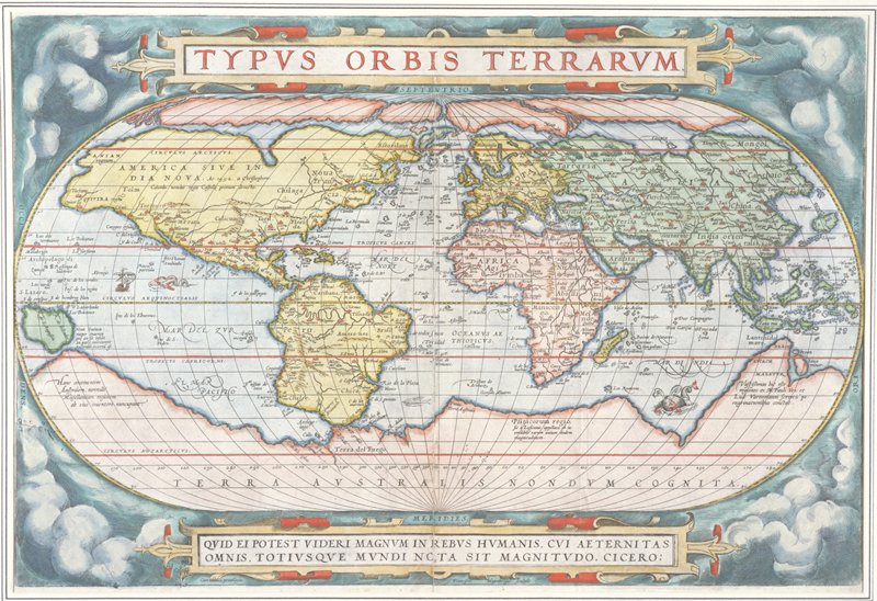
Map of the World, from Theatrum Orbis Terrarum (Theater of the Whole World), Antwerp
Minneapolis Institute of Art

View of Amsterdam
Minneapolis Institute of Art

Scenographic View of the Southern Hemisphere with the Starry Vault and the Earth, plate 28 from Harmonia Macrocosmica
Minneapolis Institute of Art

Album of landscape etchings
Minneapolis Institute of Art

Titelbladontwerp voor Atlas Contractus van Johannes Janssonius van Waesberge
Rijksmuseum

The Southern Stellar Hemisphere of Antiquity, plate 27 from Harmonia Microcosmica
Minneapolis Institute of Art

Map of the World
Minneapolis Institute of Art

View of Amsterdam
Minneapolis Institute of Art

Frontispiece from Atlas
Minneapolis Institute of Art

New Plan of Rome
Minneapolis Institute of Art

Title Page, from Creation of the World
Minneapolis Institute of Art

Spherical Scenograph of the Celestial and Terrestrial Northern Hemisphere
Minneapolis Institute of Art